
At A Glance
EMERGENCE: Between 80 million and 150 million years ago
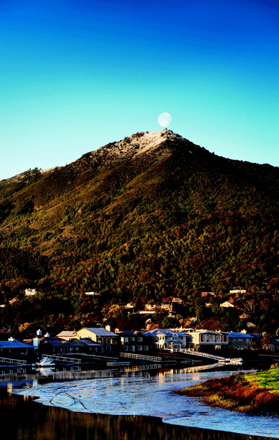
ELEVATION: 2,571 feet
TRAILS: More than 60 miles
ANNUAL VISITORS: 800,000
HIGHEST SUMMIT: East Peak is reportedly the highest of the three summits (West, Middle, East). West Peak was originally the highest but the military shaved off 28 feet in 1950 to accommodate an air force station. But according to new as-of-yet-unconfirmed measurements, West Peak may still be the highest summit, with an elevation of 2,576 feet — still just a few feet higher than the East Peak.
CAMPGROUNDS: Five, including Steep Ravine Environmental Campground (seven campsites, 10 cabins), Alice Eastwood Group Campsite (two group sites), Pantoll Campground (16 campsites), Bootjack Campground (15 campsites) and Frank Valley Group Horse Camp (25 campsites).
FAUNA: Raccoons, gray foxes, squirrels, bobcats, coyotes, black-tailed deer, mountain lions and more than 150 species of birds
ROCKS: Sandstone, shale, greenstone, chert, quar tz, tourmaline, green serpentine
FLORA: More than 750 plant species, including these wildflowers: California poppies, lupine, Douglas irises, goldfields and shooting stars
OWNER: The land is partially owned by the California State Parks system, with the remaining portion belonging to the Marin Municipal Water District.
PARKING: $8 at Pantoll, Bootjack and East Peak
PARK HOURS: 7 a.m. to sunset
FOR MORE INFORMATION: 415.388.2070, parks.ca.gov
History
Mount Tamalpais Scenic Railway
From 1896 to 1926, locals and visitors climbed the mountain via the Mount Tamalpais Scenic Railway — otherwise known as the “Crookedest Railroad in the World”; the tracks boasted 281 curves. The project was funded by a group of passionate and moneyed Marinites, including Sidney B. Cushing, Louis Janes and the Kent family, with the intent of transporting passengers from Mill Valley to Bolinas; due to a fi nancial depression in the 1890s, the operation was scaled down, resulting in tracks that ran from downtown Mill Valley to the summit of Mount Tamalpais and from the summit down to Muir Woods. The winding 2,200-foot climb from Mill Valley’s depot to the top of the mountain took a little over an hour at 10 mph. The West Point Inn was built in 1904 as a stopover, and once at the summit passengers visited Mount Tamalpais Tavern, a hotel and restaurant that often hosted dances and other events. But perhaps the most innovative aspect of the railway was the introduction of gravity cars — engineless, open-air vehicles invented by mechanic Bill Thomas. The cars were originally used to take passengers (a 1914 ride is shown) on a leisurely ride from the summit to Muir Woods, but later traveled the eight miles from the top of the mountain to Mill Valley, a journey that took 45 minutes at the mandated 12 mph. The cars seated 20, were equipped with one or two brakemen and, once at their destination, were dragged back up the mountainside by locomotives running in reverse. By the 1920s, automobiles were able to traverse the mountain more easily, and a fi re in 1929 sealed the railway’s fate — the tracks were pulled up in 1930. Old Railroad Grade and the gravity car replica that now sits in Mill Valley’s Depot Plaza serve as reminders of the historic railroad.

The Mountain Play
The idea for the Mountain Play originated with a director named Garnet Holme during a walk through Rock Spring, a popular hiking area and future home of the Cushing Memorial Amphitheater. Holme directed the first play, Abraham and Isaac, in 1913; its success drew the attention of nature-minded locals. The Mountain Play Association formed the following year in an effort to make the shows an annual event (Tamapla, 1923, is shown). William Kent quickly joined up and deeded the land to the association (the theater is now owned by the state park). The Greek-style amphitheater was dedicated in 1915 to Kent’s friend Sidney B. Cushing, whom Kent credited as a true proponent of the conservation of Mount Tam, but it wasn’t until 1933 that the Civilian Conservation Corps laid the serpentine rocks that make up the seats of the theater we know today. In 1977, the Mountain Play Association asked local marketing talent Marilyn Smith to take over as executive producer, and Smith agreed to, on one condition: that the Mountain Play center on Broadway-style musicals. The Mountain Play, now a million-dollar enterprise, celebrated its 100th anniversary last year with a production of The Sound of Music and the release of the book Marin’s Mountain Play: 100 Years of Theatre on Mount Tamalpais, by Point Reyes resident Elisabeth Ptak. Current executive producer Sara Pearson attributes the Mountain Play’s success to its uniqueness: “It’s the combination of the natural world, that beautiful historical amphitheater and the wonder of seeing live theater outside. Those three elements make the mountain play unlike any other experience.”
The Dipsea Race
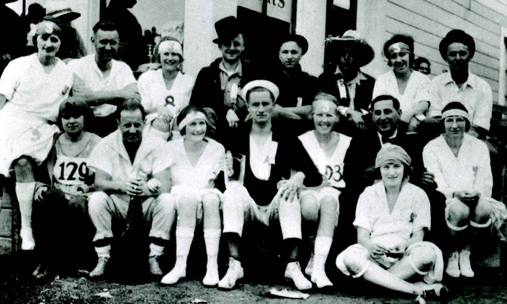
Mount Tamalpais is also home to the second oldest cross-country race in the country: the Dipsea Race. The race began as a meager enterprise: A few members of San Francisco’s Olympic Club created a hiking group called the Dipsea Indians one day while dining at William Kent’s Dipsea Inn and soon staged a two-man race over Lone Tree Trail. The event attracted so much attention that the group decided to make it an annual event. The first official Dipsea Race in 1905 was won by G. Hasard in one hour and 12 minutes with a 10-minute handicap; 90 contestants finished the race (a women’s hike circa 1918–1922 is shown). Now run every year on the second Sunday in June, the race starts in Mill Valley at the Dipsea Stairs, where participants climb 420 feet via 671 redwood steps to the top of Windy Gap. The path then drops down to Muir Woods, goes up the southern slope of the mountain, passes Lone Tree, descends into Steep Ravine and climbs again before ending at Stinson Beach — in all, a 7.4-mile run. The race that began with just two men is now run by about 1,500 participants (the maximum allowed on the trail at one time) and is supported by a group of devoted volunteers and sponsors.
Clubs and Mount Tamalpais State Park
Mount Tamalpais has been a haven for hiking and conservation clubs since the early 20th century. The park, established in 1927, was fully operational by 1930 thanks to the generosity of William Kent and his heirs, who donated a total of 1,000 acres over the course of 30 years, and land acquisition efforts by a number of groups. The first of these organizations, the Tamalpais Conservation Club, was formed in 1912 after two avid hikers, R.F. “Dad” O’Rourke and S.M. Houghton, stumbled upon hunters carrying the carcass of a young deer in Rock Spring. The men approached William Kent, who owned the area, and together they assembled a group of like-minded naturalists for the club’s first unofficial meeting on February 18, 1912. The TCC went on to sponsor cleanup campaigns, build trails and bridges and generally strive to live up to members’ self-imposed role of “Guardians of the Mountain.” In 1913 another notable group, the California Alpine Club (shown here on the stage road in 1917), formed to celebrate Mount Tam with hikes, picnics and a club-produced publication called Trails. The next year, Nature Friends, a Marin offshoot of the Vienna club Touristenverein Die Naturfreunde, made a home on the mountain; the club’s iconic Swiss-chalet lodge in Fern Canyon, a gathering place for hikers, is still fully operational, though it is currently closed to visitors.
Miwoks and Legend
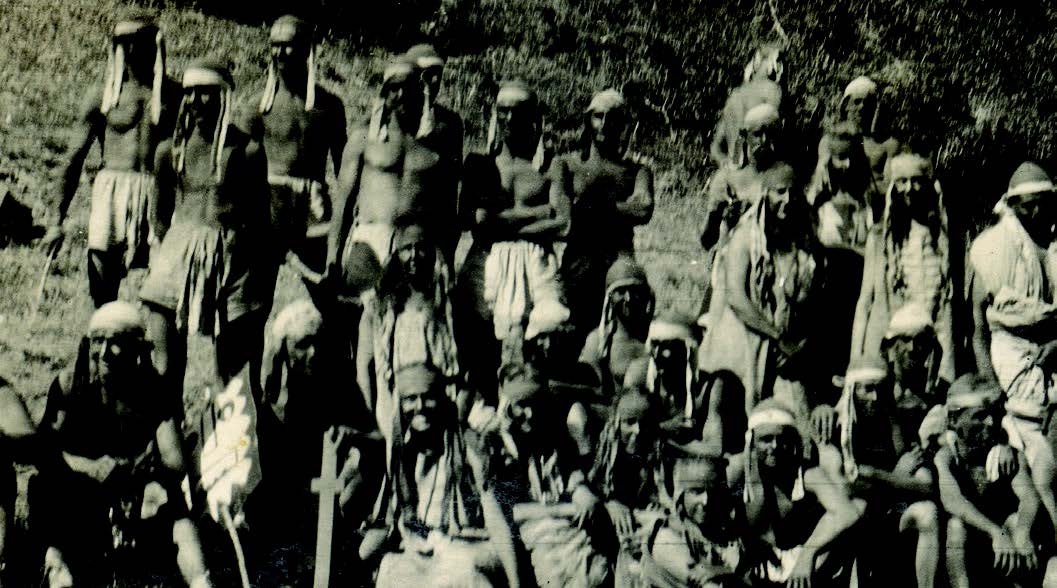
The Coast Miwoks are thought to have lived on or near Mount Tamalpais for around 10,000 years before Spanish settlers arrived in Marin. Hunter-gatherers with 14 tribes and a rich cultural identity, they dwelled, as their moniker implies, mainly near the coast, thriving there until around 1770, when explorers “discovered” the land. Their relationship to the mountain is a mysterious one. According to their creation story, transcribed by C. Hart Merriam, the Coast Miwoks believed the mountain to be the domain of the god Coyote — a holy place not to be trampled on. One account tells of trader Jacob Leese attempting to lead a party of Miwoks to the summit so he could take a look around; the tribe refused to accompany him, saying the summit was inhabited by wicked spirits. No one really knows whether the Coast Miwoks ever made their way to the top of the mountain, but one widespread myth has been debunked: the story of the Sleeping Lady. Commonly assumed to be a Miwok folk tale, the story of Tamalpa — which supposedly translates to “sleeping maiden” — was actually written by Dan Totheroh for the 1921 Mountain Play of the same name (the cast of the 1923 play is shown). Director Garnet Holme wanted to do a play centering on a native legend about the mountain, but after much research, Totheroh failed to find any such piece of folklore. So he made one up. The play told of a maiden named Tamalpa and her love for a young warrior; after it is revealed their relationship is doomed, she is fated to lie atop the mountain forever. Tamalpa was performed several times between 1921 and 1970, and the “legend” became increasingly pervasive in the community. Author Elisabeth Ptak unearthed the true backstory while writing her book Marin’s Mountain Play. “People are always surprised that the Sleeping Lady myth is not, in fact, an actual myth,” she says. “But through its repetition, it has become a sort of modern legend.”

With more than 60 miles of trails in Mount Tamalpais State Park, choosing one can be a workout in itself. Here are a few of our favorites.
Loops
1) Start at Ridgecrest Boulevard (Mill Valley): Mountain Theater Fire Trail/Old Mine Trail/Old Stage Road/Easy Grade Trail/Rock Spring Trail. 2 miles, 1.5 hours, easy
2) Start at End of Bolinas Road (Ross): Cataract Creek Trail/High Marsh Trail/Kent Trail/Helen Markt Trail. 7.7 miles, 4.5 hours, moderate
3) Start at Belvedere Avenue (Stinson): Matt Davis Trail/Steep Ravine Trail/Dipsea Trail. 7.3 miles, 4 hours, difficult
To the Top
1) Start at end of Crown Road (Kent Woodlands): Indian Fire Road/Eldridge Grade. 4.5 miles to the top, 3.5 hours, moderate
2) Start at Dipsea Steps (Mill Valley): Dipsea Trail/Sun Trail/Redwood Trail/Hogback Fire Road/Old Railroad Grade/Fern Creek Trail. 9 miles to the top, 7 hours, moderate
3) Start at Phoenix Lake (Ross): Fish Gulch Trail/ Collier Springs Trail/Northside Trail. 6 miles to the top, 5 hours, difficult
For Out-of-Towners
1) Start at East Peak Parking Lot (Mount Tam): Verna Dunshee Loop. 0.7 miles, 30 minutes, easy
2) Start at Mountain Theater (Mount Tam): Rock Spring Trail/West Point Inn. 1.5 miles, 1 hour to West Point, moderate
3) Start at Rock Spring Picnic Area (Mount Tam): Cataract Trail/Alpine Lake. 3 miles, 2 hours, moderate
What’s That?
1) PLANE REMAINS In November 1944, a navy seaplane crashed near Double Bow Knot; pieces from the wreckage can still be found at the site. In October 1945, two navy fighter planes collided over Rock Spring; one engine is still visible in Cataract Creek just above Ray Murphy Bridge.
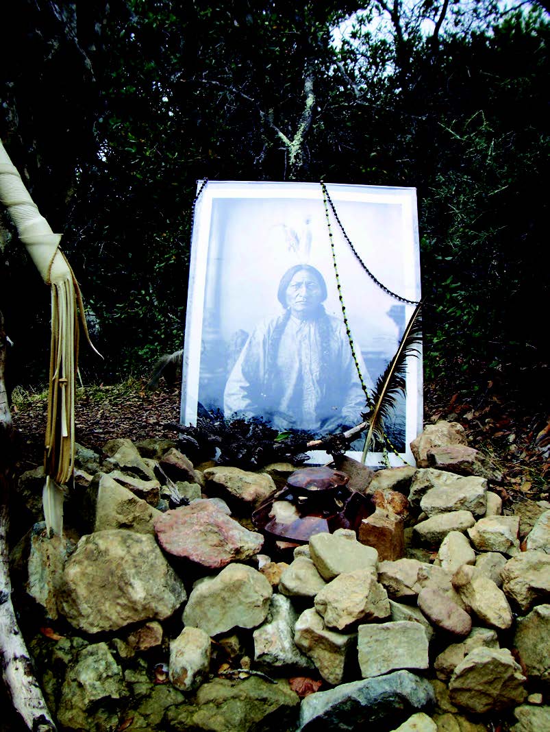
2) SITTING BULL Sitting Bull Rock (pictured), an altar to the Sioux leader, is tucked away on Temelpa Trail. The site includes a plaque engraved with a speech by Sitting Bull about the dangers white men posed to the wilderness and a weathered poster featuring his own likeness. The original plaque was vandalized and replaced.
3) GHOST CAR The rusted body of a car has been blending into the scenery near Willow Camp fire road since the 1970s, if not longer. The vehicle’s origin is unknown, but its remains are a popular spot for the creation of mini art installations.
4) RADAR DOME What looks to be a giant golf ball atop the mountain’s West Peak is actually a Cold War–era air defense radar station. The site also held radar equipment during World War II and was one of three pieces of land leased to the War Department by the Marin Municipal Water District from 1942 to 1950.
5) MAIDEN LANES A nondescript cinder-block building on West Peak was once a two-lane bowling alley, built by the air force so that some 300 servicemen stationed there (from the mid-1950s until 1981) could unwind.
